Wednesday, August 25, 2010

Grinnell Glacier Hike

We were pleased when we heard that the Grinnell Glacier trail had been reopened. It was shut down previously for bear activity. This was where Jack Hanna (TV nature guy...) had to use pepper spray on a young grizzly. We had been wanting to do this hike, but thought it was not going to happen. We actually had tried once, but arrived at the boat dock to threatening weather. We waited and came back another day. It still wasn't amazing weather, but we had purchased the boat tickets and decided to go for it.

The first part of the hike was two quick boat rides. We took the hiker shuttle boats across Swiftcurrent Lake and Lake Josephine. This allowed us to join in the ranger led hike to Grinnell Glacier. We thought that with all the bear activity here, it would be a safe way to go. The ranger's name was Monica, and we had heard her give a talk on the geology of glacier once already this summer. She was a young, recent college graduate and we enjoyed her presentation very much.
This is a look at Lake Josephine and the boat dock where we started after we had climbed just a bit up to the ridge where we would do most of the miles. We had a large group of people on the hike, and since the abilities were very scattered, the pace was slow and "stop and go". Whenever Monica stopped for a bit she gave information about the plants, animals, or geology of Glacier. We learned a lot, but after awhile we got tired of being with all the people. This was especially true because the lady directly ahead of us was someone that would stop dead in her tracks with no warning to look at a plant, pick a berry, etc. I almost crashed into her several times.

When the group decided to stop for a 15 minute snack break, we decided to continue on our own. It was cold, and we didn't feel the need to stop for that long since the pace had been really slow.
Above is an attempt to show the sun breaking through the clouds. It didn't come out as nicely as we hoped, but the sun was like a spotlight moving over the forested sections. It was pretty cool.
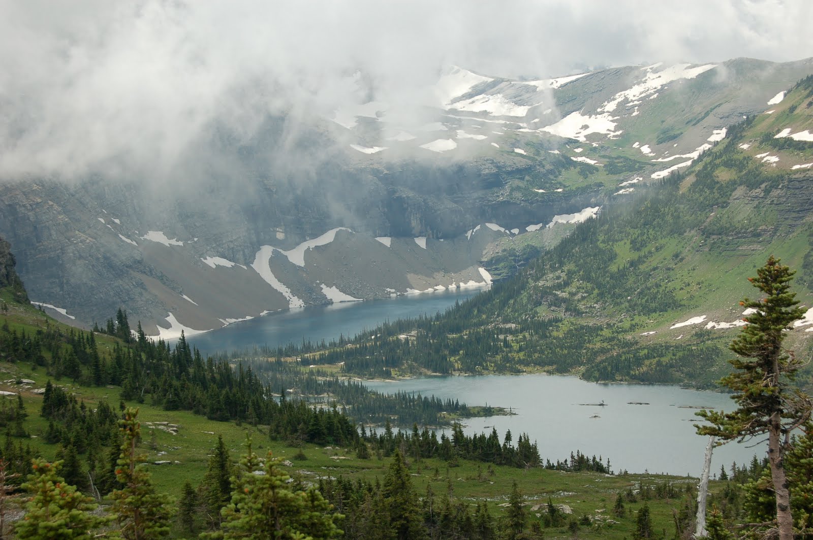
In this photo above, you can see where we are headed. The large snow area at the top is Salamander Glacier. Just below it, (hidden) is Grinnell Glacier. We will be going above that waterfall and almost to the rock wall below Salamander Glacier. The waterfall is Grinnell Falls.

This is a view of Grinnell Lake. It lies beneath Grinnell Falls, which flow from Grinnell Glacier. Have you noticed how everything is named Grinnell? Well, it was all named after George Bird Grinnell. He was an environmentalist that explored the area and was instrumental in getting the area named a national park.
Just in case you were tired of mountain photos, here is one of trees. Glen did try his hand at photos of many things this summer. :)

After we left the group at the snack break, we approached this waterfall. We knew that we had to go through it. We aren't sure that everyone on the hike was thrilled about this, and even we had some questions: "Just how wet are we going to get?" So here is our time-lapse sequence of Terry going through the falls.
Planning the route.....
Beginning through.....but careful not to go fast enough to slip over the left edge.
Deciding that the water was COLD and going a bit faster......
Mostly through. The right half of the body is now wet. That doesn't show up in the photos, but trust me....it was wet and cold. And knowing we have to come back through it doesn't help.
A closer view of where we are heading. Now you can see parts of Grinnell Glacier.
And....now the area below the glacier that is melting into a small lake above the waterfall.
You can see the lake, the glacier to the left, and Salamander Glacier above. Glen says the salamander is peeing.....boys will be boys!
Anyone for a swim?

Glen posing by the beautiful view. Raingear is now on as it has started to sprinkle. We head back to the picnic area just a bit down the trail from here, eat lunch, and then head back. We met the ranger led group again just as we finished up lunch and were ready to head out.

We were able to hop on the first boat when we returned to the dock, and the only wildlife we saw was a bighorn sheep. We were glad to have done this hike, and would say it has good "bang for the buck". It isn't overly steep or long, and has good payoff. We know now why it is a popular hike. If you wanted safety in numbers, the ranger led hike is a great option.

We only did one more hike while we were there, so the blog updates are almost done.

Tuesday, August 24, 2010

Short, but sweet

We were running out of longer hikes in the park, and decided that we might want to try some of the hikes that were commonly done by people that visited our campground. We had a lot of people looking for short, easy hikes to get out and explore a bit of the park without having to be in great shape. So, we tackled two of the more popular hikes.

First, we hiked to Avalanche Lake. This trail goes beside a creek and hikes into a lake where you can see some tall waterfalls coming down the hillside from the glacier above. It is a very busy trail. That was one of the first things we noticed and have to say it is a different kind of experience. It reminded us of Yosemite where things were just so packed with people that it didn't feel like hiking.

With that said, it was an opportunity to see some pretty things without a long hike. It did have rolling hills and was certainly challenging for some.
This is the lake at the end of the hike. It was an overcast day, and in fact did rain on us before we got back to the car, so no brilliant blue sky or water in the photos. It was a nice place to have a picnic lunch, dip the toes, and drink in some scenery. There was a ranger there telling of the days when the glacier above would have been visible there and how he used to go ice climbing there.
A closer look at one of the waterfalls.


An even closer look at the water in Avalanche Creek.
Another popular hike in the park is to the Hidden Lake Overlook. We had tried to put this in the itinerary when we were visiting with Kyle, but parking issues prevented us from accomplishing it at that time. The hike begins at Logan Pass, and takes you through an alpine meadow to an overlook of a hidden alpine lake.
Along the way, we were treated to some mountain goat action. We also had to make our way through some snow even though it was August! We had waited and waited for the snow to melt out and didn't have time to wait any longer. When we first arrived in June, people were heading up this with skis and snowboards to then ski/board back down.

Above is the payoff. The hidden lake. You can't see this from the "Going to the Sun Road" or from the visitor's center at Logan Pass. But, with a short 3 mile round trip walk, what a treat. There isn't a lot of elevation gain, and much of it is actually on a wooden boardwalk. Along the way you pass through wildflower meadows and are surrounded by mountains. This is certainly a great hike for people of all ages and fitness levels.

Thursday, July 29, 2010

Pitamaken-Dawson Loop: Or...our new favorite hike of all time!

We have a new winner! This week we tackled a hike that we have been looking at for awhile. It is a long one, and we kept debating whether we wanted to try to get a backcountry permit and take the big packs to stay overnight part of the way in, or just take day packs and make a long day of it. We finally opted to just do it as a day hike. What's wrong with a few more miles, anyways? Glen will always vote for a longer trail if it lightens the pack.

This hike is listed as a "backpackers must-do" hike in our book, and we had heard good things from our Glacier friends. They are all right! The trail is called the Pitamaken-Dawson Loop. It is 17.6 miles.(When we started the hike we thought that it was going to be just over 15, but we missed something when we were reading the description.) It starts at lake level, circles the back side of a mountain, travels past an alpine lake, climbs the side of a mountain, crosses a ridgeline, circles the back of another mountain, more ridge, around a third mountain, and then descends into a valley and back along the lake.


This is a look up at one of the mountains. We will actually be heading behind it later.


Above, is looking down on Oldman Lake where we would have spent the night if we tried to get a backcountry permit. We have climbed up some switchbacks from there to Pitamaken Pass. When we get up there, we not only see this view of where we came from, but we see another valley on the right hand side of us with two lakes. We can also see where we are headed. In that photo, we will be going behind the mountain on the right, across the ridgeline, and behind the mountain on the left around to a valley where we descend.
This is the view from the ridge on Pitamaken Pass of the two lakes on the right side of us as we could also see Oldman Lake on the left of us.
Terry could not resist this "boot shot" from the top of Pitamaken Pass. Needless to say, Glen didn't get anywhere near the edge -- personal growth only goes so far.

After we came over Pitamaken pass we saw a whole herd of bighorns, and climbed up a slope and over a snow field to get behind that mountain you saw earlier on the right side of the photo. This was the view we were treated to on the backside, as another whole valley opened up below us.
This was our lunch spot, and it was so windy we thought we would lose our hats. Hence, hat hair in the photo. Another hiker was so kind as to take this for us as we munched our pepperoni, cheese, Triscuits, and Gatorade. You can see the view behind us, and it was equally as beautiful in front of us.
This photo shows the view in front of us at lunch.

When we finally came around Dawson Pass and could see this view, we could see our ending point...at the far end of that lake. We still had lots of miles to go to make it there, but what a phenomenal hike. We have never had a hike with so much of it above treeline, with so many different viewpoints.

It WAS a LOOONG hike. However, we are glad we did it with light packs. We also know that if we were ever to have anyone ask about overnight stays, that our advice would be to get one or two nights at Oldman Lake. Hike there, drop the gear, take light packs up and over Pitamaken and around to Dawson, then go back to Oldman Lake and out the same way. The Dawson Pass side is steep, you can see all the view from the top, and no way would we do this in reverse order. Pitamaken has nice gradual switchbacks. :-) We didn't really enjoy the part where we came down from Dawson into the lake level. It was a bit hard on the knees!

If you time things correctly, you can cut about 2 miles off this hike by taking the boat across Two Medicine Lake. We didn't time things correctly. They run boats at 3:00 and at 5:00. We reached the boat area about 3:10. So, we opted to walk out rather than wait 2 hours for a boat.

We are slowly reaching the end of our "must do" list here, and that is probably a good thing. Many trails are being closed for bear activity. We wanted to hike to Grinnell Glacier, but doubt we can now. I don't know if you all heard the story of Jack Hanna and the grizzlies that resulted in him spraying a young griz....but it was all the rage here. Jack Hanna Article Jack Hanna actually stayed here at the KOA and he very kindly gave me an autographed copy of one of his books when he heard I was a 4th grade teacher.


Sunday, July 25, 2010

Old Favorites Repeated: Ptarmigan Tunnel and the Highline Trail

This week we decided to hike two hikes that were favorites from when we were here two years ago. First, we did the Ptarmigan Tunnel trail. Glen had hiked it with Kyle last time, but it was new for Terry. The photo above is Ptarmigan Lake where we stopped to rest and enjoy some Clif bars before continuing to climb up to the tunnel.

Just past the lake we saw the biggest marmot we have ever seen. Glen says it was the "king" marmot! He was the size of a small beagle. (Watch out, Rosebud!)
Above, you can see Terry going through the tunnel. It was carved out here and was used by people and horses in the early days in the park. It still can be be accessed by horses, and we actually saw one girl on her horse on the trail the day we hiked it. There are big metal doors to close off the tunnel in the winter. Unlike most tunnels where cars or trains go through near the bottom of the mountain, this tunnel is near the top.

Here is the view you see when you go through the tunnel. It is a valley and lakes that of course is hidden the entire time you are climbing the other side of the mountain.
Glen is posing in front of the great view. We stayed for a few minutes and admired the view, saw the local marmot, and then went back through the tunnel to head down. We saw a bighorn sheep on our way down.
There were several beautiful waterfalls on the hike. In fact, there were many photographic opportunities. We saw one couple with big backpacks and asked where they were camping overnight. It turns out that the packs were full of photography equipment! We decided they were tough cookies!! Can't even imagine hauling all that to the top of mountains.
The wildflowers are still in bloom, and the devils' paintbrush are coming out. We like this rose colored version of that.

When we got back to the trailhead, we were greeted with a note on our car. It was actually the second time we have had this happen this summer. This one was from a couple from Aroostook County. They saw our license plates and put a note telling us their campsite number and that if we were around in the evening, they would be back and would love to visit. Previously, in Banff, we had a note on our car that just said, "Go, Black Bears!!" We did try to look that couple up, but they were not in their campsite when we went by. Small world!

After a rest day, we were ready to tackle the Highline Trail. This was one we did before on a cloudy, misty day. This time we were treated to brilliant sunshine, and it was a beautiful hike.
When we arrived this summer, the trail sign was just barely sticking out of the snow. You can see that isn't the case now, but there are still traces around.
Mountain goats love this trail, and once again we were treated to many sightings. This one tried to chase Glen a bit, but mostly just wanted to eat!
Views were crystal clear that day and we decided to take lots of photos.
We also decided to take a side trail to Grinnell Glacier Overlook. It climbs 1000 feet in 8 tenths of a mile. (Steep!) Partway up, Terry was questioning the wisdom and wondering if the payoff was worth it. Answer....yep!
Above, you can see the view we earned as we look down on the lake that the glacier is melting into.

Glen once again showing the scale of the view. Then, we descended back down to the Highline Trail and hiked to the Granite Park Chalet. This was our lunch spot.


After the chalet, we hiked downhill to the Loop. This is a location on the Going to the Sun Road where we had left our car that morning. It was an interesting ending as we hiked down with a gentleman from Massachusetts, and we talked all the way.

This ending was different for us, as two years ago we had taken another trail after the chalet.
So, while the two trails this week were somewhat repeats, each had something new about them and we enjoyed them immensely.
Until next time,
Terry and Glen

Wednesday, July 14, 2010

Banff, Lake Louise, Icefields Parkway, Columbia Icefield


Banff National Park in Alberta, Canada. This was the setting for a four-day mini-vacation. The photo above is from Lake Louise, and we'll give you more details about that area below. We didn't have to earn this particular shot -- even the tourists in flip flops or Guicci loafers were treated to this view -- but that just made some of the other views taste even better.

We drove north, through Calgary, and then west to Banff. Getting through Calgary was a bit more complicated than we expected. (Stupid Walmart Atlas!!!) As the driver, I am willing to admit that it WAS the map, not the navigator that made Calgary a fun time. It was time for the Calgary Stampede, and we ended up driving right through the excitement. An hour later, we did make it through Calgary and were on our way. We snagged a campsite in Tunnel Mountain Campground and then proceeded to explore the town.

The city/town of Banff itself, is like Bar Harbor on steroids. Picture shops, restaurants, and a bazillion tourists, but instead of being located on the ocean it is surrounded by mountains. The first challenge was to find a place to park, and once that was accomplished, we had to choose between dozens of places to eat. Yeah, life's tough. After dinner in a local restaurant, we tried to get back to the campground. It seems that between the time we got our site, and the time we tried to return, everyone from Calgary had finished the work week and wanted to camp in Banff. There was a long line trying to check in to the campground. It would take people over an hour to get from the road into the gatehouse. When we finally got back to our site, we had a good view of the line, and it never ended until they closed the gate at 11:00 pm. I guess we won't complain any longer when we have a few customers in our KOA lobby.

One cool thing about Canada's national parks is that when you sign up for a campsite, they ask you if you want a fire ring. If you say yes, you pay a fee/day. Then, they have this gigantic pile of firewood that you go to and take what you want. So, instead of trying to find a local selling small bundles of wood for exorbitant amount of money, you can really make a fire. We enjoyed this perk all three nights we stayed there.
We were up and away early to go to the Lake Louise area of the park. We wanted to do a hike to "The Plain of Six Glaciers". It starts out around the shore of Lake Louise, and then climbs up to an old tea-house built in the 1920's. (I think-anyway it IS old) All along the way you have incredible views of glaciers ahead of you. It's easy to see why this area has so many visitors, when views like this are accessible to everyone.

We did have to cross a few wet spots. This is where I was wishing I had my waterproof hikers on. I chose to wear just my trail sneakers....and it worked out fine. My rock balancing skills paid off! The camera man was ready just in case of a spill, but things went smoothly.

Above you see some of the glaciers and we actually heard this one break off. It sounded like thunder and echoed off the surrounding mountains. It looked like waterfalls coming off the glacier, but it was really snow. It happened twice while we were on this hike. Now we come to the views that we had to earn, and for some strange reason those pictures always seem to be more beautiful.

This is the view looking back when we had climbed awhile. We started the hike at the chateau you can see at the far end of the lake.

This is after one of the pieces broke off the glacier. You can see the snow falling down like a waterfall. The first time that this happened, we actually thought that we were looking at a waterfall. It wasn't until the snow stopped falling that we realized what must have happened.

This is at the tea house. We had scones with strawberry jam and tea and lemonade. Wish all hikes had a tea house at the top of the climb! It's amazing how good dry scones and tea can taste -- nothing like a hike to whet the appetite.

This big boy was waiting for us the following morning as we decided to drive the Bow Valley Parkway on the way to the Icefields Parkway. We had decided to spend the day on a scenic drive and visiting the Columbia Icefields visitor center.


This is a view of the meltwater and the blue ice on the glacier. The dirt is because glaciers are made from compressed snow. Snow forms around a center of dust or dirt, so when it melts the dirt is left behind.

This is Glen standing on the glacier. It was pretty cold and slippery. We aren't ready to try ice climbing any time soon! It felt like we were standing on a few feet of snow and ice, but the glacier was actually 1000 feet thick at this point.


This big ice bus took us a mile out onto the glacier. It is an amazing machine, but we don't want to buy one. Each one costs a million and a half!! And each tire is $6200.

This is looking from the ice bus to the side on the return journey. You can see the side moraine and above it, is another glacier. I think it was called Double A glacier as the mountains on each side both began with the letter A.